The Complete Hehuanshan Guide: Public Transport, Driving, How to Plan 2–3 Days, and Where to Stay
Hehuanshan peaks 合歡山群峰 are the most accessible 100 Peaks in Taiwan. Still, the accessibility doesn't
compromise the beauty of the spectacular views of the high mountains that can be found only in Taiwan.
Moreover, you don't need to apply for a hiking permit.
This post is a complete guide to hiking the 11 peaks of the Hehuanshan area and what to expect. Plus, the
things you need to know, like the weather, traffic control, and public transport before you hike. Also, a stunningly beautiful place
as a bonus if you opt for a more challenging route.
Disclaimer:
All content is for inspiration only. Use Taiwan Hikes' suggestions at your own risk. We are not responsible for any losses, injuries, or damages.
All content is for inspiration only. Use Taiwan Hikes' suggestions at your own risk. We are not responsible for any losses, injuries, or damages.
Table of Contents:
- Hehuanshan's 11 Peaks: Taiwan's Most Accessible, Permit-Free High-Mountain Hikes (With Maps)
- How to Get to Hehuanshan: Public Transport, Parking, and Where to Stay During Your Hehuanshan Hike
- The Peaks Worth Planning Around on a Tight Schedule — Main, East, North, Mt. Shimen
- The One Real Challenge — West Peak (out-and-back / Huagang)
- The Rest — South Peak, Hehuanjian, Shimen North, Little Qilai, Haha, Nanhaha
- Before You Go: Road Closures, Winter Rules, Weather, Drones & the Rules Nobody Mentions
- About Hehuanshan and the Only Ski Resort in Taiwan
- Related Posts
Hehuanshan's 11 Peaks: Taiwan's Most Accessible, Permit-Free High-Mountain Hikes (With Maps)
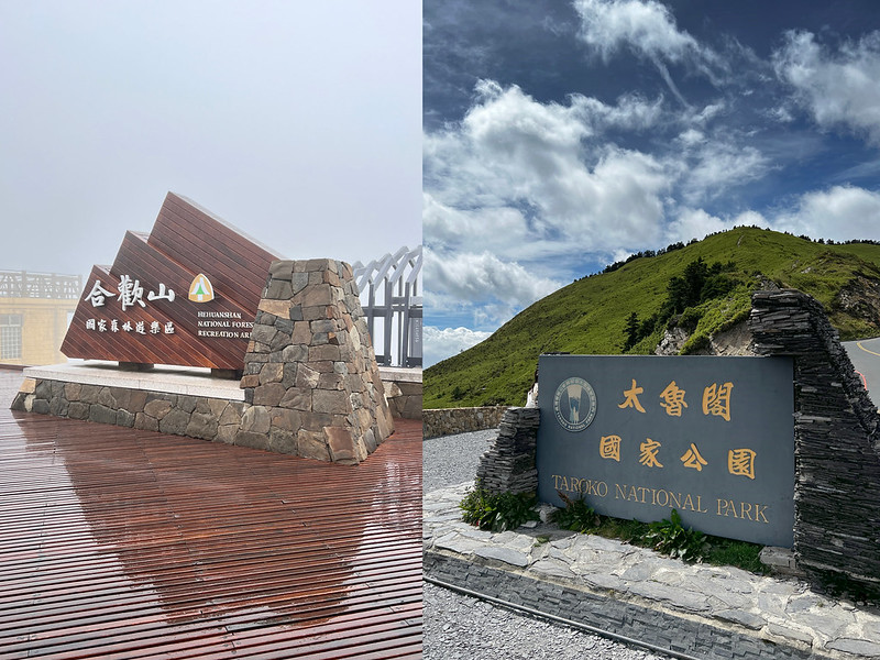
The Hehuanshan area is managed by several government agencies for the trails, traffic, and more, including the Taroko National Park and Hehuanshan National Forest Recreation Area.
There are 11 Peaks in this area and you can hike without a permit. The trailheads to those peaks are along Provincial Highway 14A 台14甲線.
- Hehuanshan Main Peak Trail 合歡山主峰, 3,417 meters (11,210.6 feet) above sea level, and is listed among 100 Peaks. There is a Class 3 Triangulation Stone on the top. Distance: a 3.6 km (2.2 miles) out-and-back trail.
- Hehuanshan East Peak Trail 合歡山東峰, 3,421 meters (11,224 feet) above sea level and is listed among 100 Peaks. Distance: a 2 km (1.2 miles) out-and-back trail.
- Hehuanshan North Peak Trail 合歡山北峰, 3,422 meters (11,227 feet) above sea level. Listed in 100 Peaks. Distance: a 3.8km (2.4 miles) out-and-back trail.
- Hehuanshan West Peak Trail 合歡山西峰, 3,145 meters (10,318.2 feet) above sea level. Listed in 100 Peaks. Distance: a 13.4km (8.3 miles) out-and-back trail. Hehuanshan North Peak is on this route if you hike to the West Peak.
- Mt. Shimen (Shimenshan) Trail 石門山, 3,237 meters (10,620 feet) above sea level and listed in 100 Peaks. There is a Class 3 Triangulation Stone on the top. Distance: a 1.4 km (0.9 mile) out-and-back trail.
- Mt. Shimen North Peak 石門山北峰, 3,275 meters (10,744.7 feet) above sea level. Distance: a 1.7 km (1.1 miles) out-and-back trail.
- Mt. Haha 哈哈山, 3,286 meters (10,780.8 feet) above sea level.
-
Mt. Nanhaha or Mt. South Haha 南哈哈山, 3,285 meters (10,777.5 feet) above sea level.
Mt. Shimen North Peak, Mt. Haha, and Mt. Nanhaha are on the same route, and Mt. Shimen North Peak is the farthest point on this route. The distance of this out-and-back route is 1.7 km (1.1 miles). - Hehuanshan Point Trail (Mt. Hehuanjian) 合歡尖山, 3,217 meters (10,554.4 feet) above sea level. Distance: a one km (0.6 miles) out-and-back trail.
- Xiaoqilai (Little Qilai) Trail 小奇萊步道. The highest point of this trail is 3,150 meters (10,334.6 feet) above sea level. Distance: a 2.8km (1.7 miles) out-and-back trail.
- Hehuanshan South Peak 合歡山南峰, 3,220 meters (10,564 feet) above sea level. Distance: a 1 km (0.6 miles) out-and-back trail from Kunyang Parking Lot 昆陽停車場.
How to Get to Hehuanshan: Public Transport, Parking, and Where to Stay During Your Hehuanshan Hike
Buses from Taichung to Puli, and to Hehuanshan
Fares & routes as of June 2026 — always check Nantou Bus for the latest. Swipe the table sideways to see the major stops.
✓ = this bus serves that stop.
Click the bus number for the timetable.
| Bus No. | Fare | Taichung HSR (Platform 3, Exit 5) |
Puli Bus Station | Qingjing Farm / Guest House |
Hehuanshan | Note |
|---|---|---|---|---|---|---|
| 6670 | NT$187 | ✓serves Taichung HSR | ✓serves Puli | |||
| 6670A | NT$118 | ✓serves Taichung HSR | ✓serves Puli | |||
| 6670C | NT$144 | ✓serves Taichung HSR | ✓serves Puli | |||
| 6670D | NT$118 | ✓serves Taichung HSR | ✓serves Puli | |||
| 6670G | NT$187 | ✓serves Taichung HSR | ✓serves Puli | |||
| 6670H | NT$118 | ✓serves Taichung HSR | ✓serves Puli | Fastest | ||
| 6664 | NT$123 | ✓serves Puli | ✓serves Qingjing Farm | |||
| 6658 | NT$123 | ✓serves Puli | ✓serves Qingjing Farm | |||
| 6659 | NT$123 | ✓serves Puli | ✓serves Qingjing Farm | |||
| Qingjing Shuttle | NT$233 | ✓serves Taichung HSR | ✓serves Puli | ✓serves Qingjing Farm | Get a number at the Nantou Bus counter at Taichung HSR Station. If passengers pay with an IC card, they need to swipe the card 4 times. | |
| 6658A | NT$95 | ✓serves Qingjing Farm | ✓serves Hehuanshan | Book round-trip seats in advance. No bicycles on board. |


Parking Lots and Payment Methods
As of June 2026, fees may be subject to change. Please verify the current fees again. All parking lots offer a free grace period if your car leaves within a certain time for a quick toilet break.
Swipe the table sideways to see all columns.
Swipe the table sideways to see all columns.
| Parking lot | Mon–Thu (car) | Fri–Sun & holidays (car) | Daily cap | Free buffer | Notes |
|---|---|---|---|---|---|
| Kunyang, Wuling & Mt. Hehuan (Hehuanshan) Parking Lots | NT$50 / hr | NT$60 / hr | NT$300 | 15 min | Motorcycles NT$20 per entry |
| Xiaofengkou Parking Lots | NT$20 / hr | NT$60 / hr | Weekday: none Weekend: NT$300 |
15 min | Motorcycles NT$20 per entry |
| Hehuanjian Temporary Parking Lots | Free | Free | N/A | Parking space is limited here. If full, use the lot near the visitor center. | |
| Yuanfeng Visitor Center / Dark Sky Park | NT$50 flat / entry | NT$50 flat / entry | 10 min | Overnight car-stay NT$300. Shuttles & medium buses park free 08:00–17:00. |
Most parking lots in the Hehuanshan area charge rates that are comparable to those at Hehuanshan Parking Lots.

Xiaofengkou Parking Lots: On weekdays, there's no daily cap, and charges round up by the hour—so leaving your car all day or overnight can add up to NT$480 (24 hours = NT$480).


Yuanfeng Parking Lots: a flat rate of NT$50 per entry. The NT$300 "overnight" rate is for camper vans at the Dark Sky Park.


Where to Stay - Option 1: Stay at Songsyue Lodge 松雪樓
Songsyue Lodge offers two types of rooms: suites that can accommodate either 2 or 4 people. Both options include breakfast and dinner. You can make online bookings through Songsyue Lodge's bilingual website.
Please note that reservations can only be made up to 30 days before your desired stay. Booking hours are from 8:00 AM to 11:00 PM GMT+8:00.

Where to Stay - Option 2: Stay at Ski Hostel (滑雪山莊) - Currently Under Renovation
Both Songsyue Lodge and Ski Hostel share the same online booking website and are under the Nantou Branch of the Forestry and Nature Conservation Agency (農業部林業及自然保育署南投分署).

Where to Stay - Option 3: Stay at Qingjing (Cingjing) Farm 清境農場
If you can't book a room at either Songsyue Lodge or Ski Hostel, staying at Qingjing Farm can be an option. You have plenty of options to choose from in the Qingjing Farm area, from the luxurious hotels to budget hostels. The distance from Qingjing to Wuling at Hehuanshan is about 24 km.

The Peaks Worth Planning Around on a Tight Schedule — Main, East, North, Mt. Shimen
Hehuanshan Main Peak
- The closest bus stop: Wuling Bus Stop. Walking distance from the bus stop to the trailhead: 0.8 km
- The closest parking lot: Wuling Parking Lot. Walking distance from the parking lot to the trailhead: 0.8 km
- Elevation: 3,417 meters (11,211 feet) above sea level
- Trail distance and route type: 1.8 km and out-and-back
- Difficulty level:

- Estimated time: 2 hours
- Also listed in Taiwan's 100 Peaks
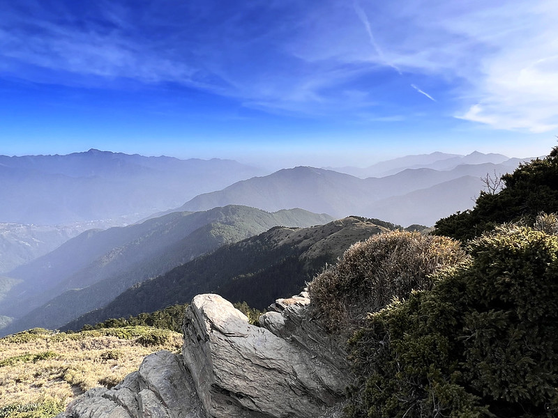
The trailhead to Hehuanshan Main Peak is close to Wuling 武嶺, 3,275 meters above sea level. Wuling is the highest point on Taiwan's highways and the saddle between Hehuanshan Main Peak and East Peak.


Follow the highway and walk toward the south, and you will see the trailhead, around the 30.8 km marker, to Hehuanshan Main Peak.

No vehicles, motorcycles, scooters, or bicycles are allowed to enter.
The trail to the main peak is easy, and you just follow the road. When the weather is good, the views are amazing.


When the sky is clear, you can see the highest and second-highest mountains, Yushan and Xueshan, from Hehuanshan Main Peak.

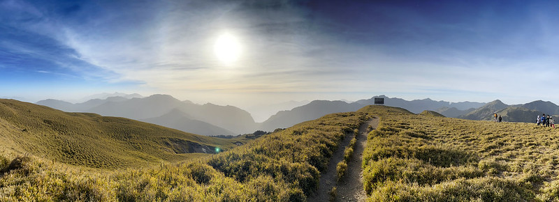
Hehuanshan East Peak
- The closest bus stop: Songsyue Lodge Stop. Walking distance from the bus stop to the trailhead: 0.45 km
- The closest parking lot: Wuling Parking Lot. Walking distance from the parking lot to the trailhead: 0.55 km
- Elevation: 3,421 meters (11,224 feet) above sea level
- Trail distance and route type: 1.056 km and out-and-back
- Difficulty level:

- Estimated time: 2-3 hours
- Also listed in Taiwan's 100 Peaks
The parking lots at Songsyue Lodge are exclusively for guests. Visitors may park their vehicles at the Hehuanshan Visitor Center. You can also find toilets and a coffee shop near the parking lots.


As you ascend the stairs, you will encounter relics from the ski resort that existed decades ago in Hehuanshan. Despite being a tropical island, Taiwan had a ski resort in the past.


The final stretch to Hehuanshan East Peak features natural terrain, which is not overly rugged. Upon reaching the summit, the actual peak is just a few meters away.


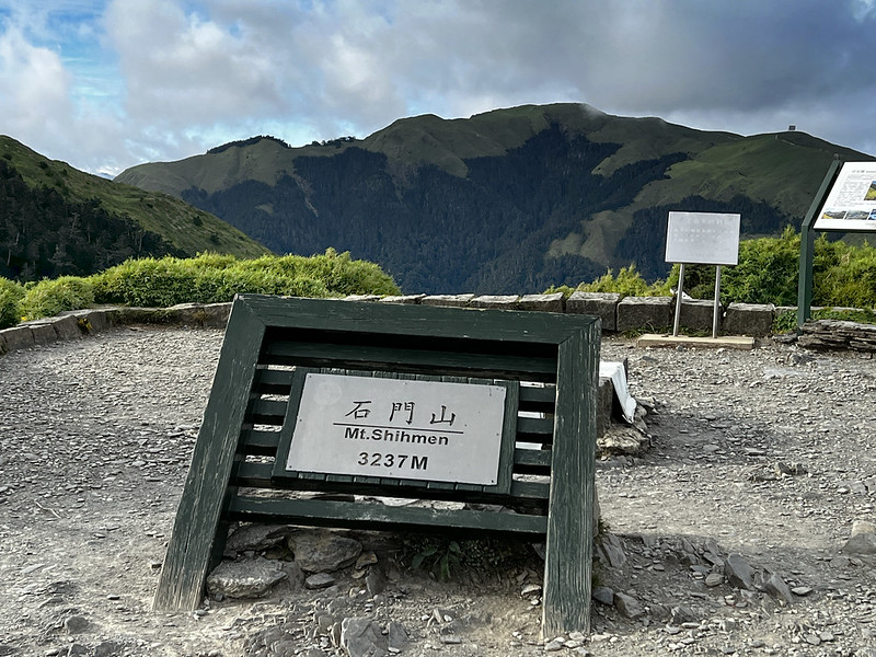
Mt. Shimen (Shimenshan), the Easiest 100 Peaks to Hike in Taiwan
- The closest bus stop: Shimenshan Stop. The trailhead is next to the bus stop.
- The closest parking lot: Hehuan Point (Hehuanjian) Parking Lot. The trailhead is accross the parking lot.
- Elevation: 3,237 meters (10,620 feet) above sea level
- Trail distance and route type: 0.8 km and out-and-back
- Difficulty level:
- Estimated time: 1 hour
- Also listed in Taiwan's 100 Peaks

The trail at Mt. Shimen is short and easy, mainly consisting of stairs, but it offers stunning views. During my second hike, I saw Mt. Hehuan Point (Hehuanjian) glowing in the sunlight, with Hehuanshan East Peak visible in the background.

Yet, the view from the top is spectacular. You can see almost most of Hehuanshan mountains from there,
especially North Peak, with the landmark reflector nearby.
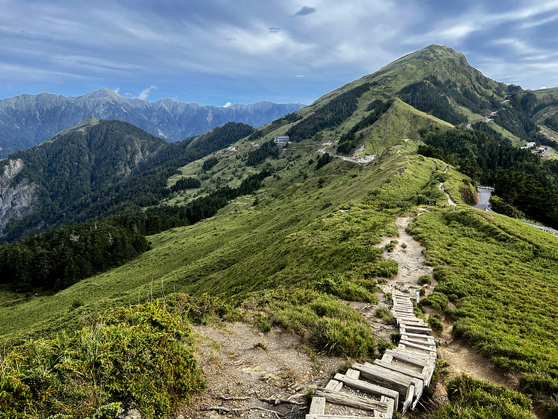
Hehuanshan North Peak
- The closest bus stop: Xiaofengkou Stop. Walking distance from the bus stop toward north to the trailhead: 0.4 km
- The closest parking lot: Xiaofengkou Parking Lot. Walking distance from the parking lot to the trailhead: 0.5 km
- Elevation: 3,422 meters (11,227 feet) above sea level
- Trail distance and route type: 1.9 km and out-and-back
- Difficulty level:

- Estimated time: 3-4 hours
- Also listed in Taiwan's 100 Peaks

Hehuanshan North Peak's trailhead is located near the 36.9 km marker. You might see cars parked along the side of the highway. But don't park on the roadside yourself, it gets ticketed.

When I first hiked to the north peak, we aimed to catch the sunrise. If you drive, you can enjoy the stunning sunrise along the way.

The path to Hehuanshan North Peak is more rugged and steeper, but it remains manageable. You will find mileage markers every 100 meters, with the last one at 1.9 km.

When you reach the grassland area, the famous landmark, the reflector, is very close. It's much bigger than I thought.


When you reach Hehuanshan North Peak, don't forget to see the grogerous Shengleng Ridge behind.
The One Real Challenge — West Peak (out-and-back / Huagang)
- The closest bus stop: Same as Hehuanshan North Peak
- The closest parking lot: Same as Hehuanshan North Peak
- Elevation: 3,145 meters (10,318 feet) above sea level
- Trail distance and route type: 13.4 km (8.3 miles), out-and-back route with over 1,300 meters of ascent and descent
- Difficulty level:

- Estimated time: 10-14 hours
- Also listed in Taiwan's 100 Peaks
There are two routes to hike Hehuanshan West Peak: a point-to-point route and an out-and-back route. However, the Huagang Creek Trail (華崗溪步道) is unstable after heavy rains, requiring multiple creek crossings, making the out-and-back route the safer option.
The descent from the north peak to Hehuanshan West Peak is steep, leading to a challenging ascent on the return journey.
Additionally, Huagang Village, the trailhead for Huagang Creek Trail, is very remote, and taxis or pickups must be arranged in advance. A few years ago, two European hikers rode a scooter to the north peak and attempted the point-to-point hike after rain but needed to call for help. Careful planning is essential before embarking on this hike.

Sunrise from Hehuanshan North Peak
If you decide to do this out-and-back hike to Hehuanshan West Peak, always start the hike early. The bonus is that you might see the stunning sunrise on the way.
Overlooking Xueshan, aka Snow Mountain, 3,886 meters, Wuling Farm, and Wuling Quadruple Mountains from Hehuanshan North Peak.


The Nortorious 7 Ups And 8 Downs 七上八下 to Hehuanshan West Peak
The following is based on my hike in 2023. After reaching the north peak, it's time to tackle the famous, or perhaps infamous, Qi Shang Ba Xia (七上八下), which literally translates to "7 ups and 8 downs" in Chinese. The mountains ahead of us were breathtaking, but the sight of all the peaks we still had to conquer was a bit discouraging.
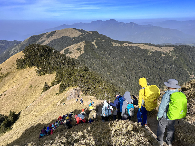

From that point, the hike primarily follows a ridgeline. I checked the map and confirmed that there are seven peaks before we reach the junction to West Peak. The trail is clearly marked, but it is still important to have a map.


The junction to West Peak and Huagang Village is also known as 3225 Peak and is located after the 5.7 km marker.


Before entering the forest, the signs indicated that the distance from the junction to West Peak was 1 km, and to North Peak was 3.7 km.

The terrain became treacherous from here, and what awaited us descended upon the ground, intertwined with tree roots.
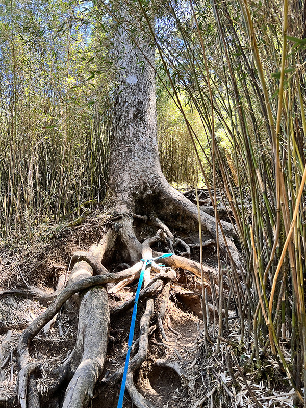
We reached the lowest point at 5.9 km and started climbing up.

The forest transitioned back to vast grassland after the 6.0 km marker.


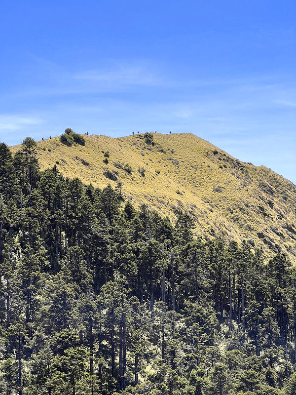
Finally, at Hehuanshan West Peak. Expect a long queue for the peak photos if you hike during the holidays.


After the break, it's time to return the way we came.
The Rest — South Peak, Hehuanjian, Shimen North, Little Qilai, Haha, Nanhaha
Hehuanshan South Peak
- The closest bus stop: Kunyang Stop. The trailhead is across the road.
- The closest parking lot: Kunyang Parking Lot. The trailhead is across the road.
- Elevation: 3,220 meters (10,564 feet) above sea level
- Trail distance and route type: 0.5 km and out-and-back
- Difficulty level:
- Estimated time: within 1 hour


Hehuanjian or Hehuan Point Trail
- The closest bus stop: Songsyue Lodge Stop
- The closest parking lot: Songsyue Lodge Lot.
- Elevation: 3,217 meters (10,554.5 feet) above sea level
- Trail distance and route type: 0.5 km, point-to-point or out-and-back
- Difficulty level:
- Estimated time: within 1 hour
I've never hiked the Hehuan Point Trail because I've been deterred by the steep stairs following my hikes to other peaks. However, I recently learned that Mt. Hehuanjian is a glacial cirque peak, and I plan to hike it someday.


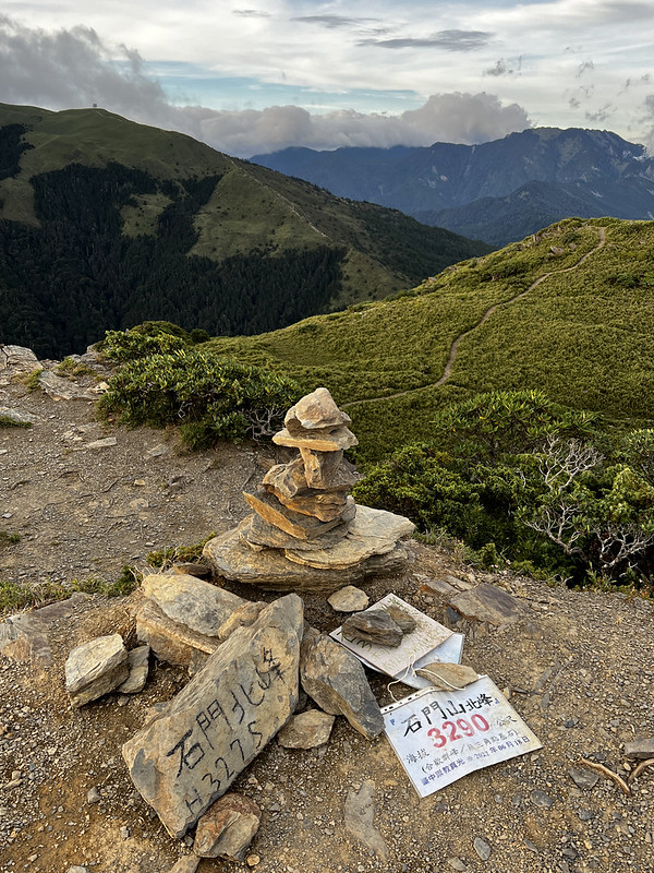
Mt. South Haha (Nanhaha), Mt. Haha, and Mt. Shimen North Peak
- The closest bus stop: Shimenshan Stop. The distance from the stop to Kenanguan 克難關 near the 34.5 km marker, aka Dafengkou 大風口 Big Wind Gap, is 1 km.
- The closest parking lot: Hehuanjian Parking Lot. The distance from the stop to Kenanguan trailhead is 1 km.
- Mt. South Haha Elevation: 3,285 meters (10,777.6 feet) above sea level
- Mt. Haha Elevation: 3,287 meters (10,784 feet) above sea level
- Mt. Shimen North Peak Elevation: 3,275 meters (10,744.8 feet) above sea level
- Trail distance and route type: 0.85 km and out-and-back
- Difficulty level:
- Estimated time: 1-2 hours
You can hike those three peaks together, and take the same way back.

Xiaoqilai Trail to Mt. Xiaoqilai
- The closest bus stop: Songsyue Lodge Stop. Walk 0.5 km to Mt. Qilai trailhead.
- The closest parking lot: Songsyue Lodge Lot. Walk 0.5 km to Mt. Qilai trailhead
- Elevation: 3,153 meters (10,344.5 feet) above sea level
- Trail distance and route type: 1.4 km and out-and-back
- Difficulty level:
- Estimated time: 2 hours
I have not hiked the Xiaoqilai Trail, which is renowned for its stunning Taiwan Alpine Rhododendron blooms in spring.


Before You Go: Road Closures, Winter Rules, Weather, Drones & the Rules Nobody Mentions
1. Winter Driving in the Hehuanshan Area: Ice-prone Sections and Traffic Control
In winter, these stretches ice over easily. Slow right down:
- Provincial Highway 14A (Wushe branch): km 37, km 38.7–39, and km 34.5 (Kenan Pass) down to km 29.3 (Kunyang)
- Highway 14A, which connects Wushe and Dayuling, experiences significant traffic jams during snowfalls and on public holidays.
- During the snow season, if the road has snow or ice, traffic control measures are implemented. Highway 14A between Dayuling and Cuifeng is closed to vehicles from 6:00 PM to 7:00 AM.
- Always check current road conditions before and during your trip, whether it's winter or not.
Snow chains (雪鏈) in winter: In the snow season, vehicles may be required to fit snow chains on iced-over sections, or the road may be closed as a precaution. Check the current road-control status before you go; it changes fast.
2. What's Banned in Hehuanshan
The Hehuanshan area is under the National Park Law, Regulations Governing the Establishment and Management of Forest Recreation Areas, and other regulations. The following behaviors are prohibited, not just on the trails:
- No stoves, open fires, fireworks, cooking, or BBQ — anywhere in the Hehuanshan area
- No smoking — the entire recreation area is a designated no-smoking zone (Kunyang, Wuling, Songsyue Lodge, Hehuan Lodge, East Peak, Hehuanjian, and all scenic spots)
- No pets — no dogs, cats, or other mammals. Hehuanshan is in a rabies-control zone; the ban protects both wildlife and your animal.
- No camping or pitching tents outside designated areas
- No picking plants, hunting, fishing, polluting water, carving on rocks/trees/signs, or playing loud music/sound devices
- No firecrackers, fireworks, or joss paper
- No parking outside marked areas, and don't block reserved spaces
- No entering closed areas, or any area during its closed hours.
3. Can I Fly A Drone in Hehuanshan?
Yes, but flying a drone in Hehuanshan requires a permit from Taroko National Park. Check Taroko National Park's regulations (Chinese).
- Where to apply: Go to the Tarako National Park's Flying Drone Application page and apply online.
- When to apply: Apply 7 to 60 days before your shooting date.
- How long the permit lasts: One permit covers a shooting window of up to 30 days.
- What do I do with the permit: After approval, carry your permit and your ID while filming, in case of inspection.
Rules While Flying A Drone
- You must comply with Taiwan's Civil Aviation Act and all related drone laws. Airflow and GPS signal are often unstable up here — mind your altitude, speed, volume, wind, and signal. Airflow and GPS signal are often unstable up here — mind your altitude, speed, volume, wind, and signal.
- No drone racing, and don't disturb wildlife or endanger other visitors.
- Do not fly over Hehuan Creek (合歡溪) — it's a restricted spot.
- You're liable for any injury or damage to facilities, landscape, or natural resources your drone causes.
- If the location is outside the park or involves another agency's facilities, residents' homes, or a business's property, obtain consent first.
- Roads, trails, and viewpoints may close due to heavy rain, earthquakes, or snow. Check the park website for current closures before entering. An approved spot that's closed on the day is treated as not approved for that period — the permit doesn't override a closure.
- Taroko will refuse your drone applications for 2 years and pursue legal penalties.
4. Always Check These Before You Depart
For snow-season traffic control, current road/snow conditions, and safety notices, check the official sites for Taroko National Park, Nantou County, and Hualien County before you set off.
- Weather forecast from the Central Weather Administration
- Traffic and road conditions from the Central Region Branch Office of the Highway Bureau
- Provincial Highway Real Time Information Service
- The Taroko National Park
- Hehuanshan National Forest Recreation Area
- iBus Information Service. You can also download the app in your phone.
Here is a list of fines for various violations. You don't need a stove anyway — there are restaurants and cafés up here, so a hot meal is easy to find.
About Hehuanshan and the Only Ski Resort in Taiwan
If you visit Taroko Gorge and continue along the Central Cross-Island Highway, you will arrive at Dayulin (大禹嶺) at the junction where Provincial Highway 14A connects. Provincial Highway 14A is a spur route of the Central Cross-Island Highway and provides access to Hehuanshan from eastern Taiwan.
Hehuanshan is located on the border of Ren'ai Village in Nantou County and Xiulin Village in Hualien County. It lies in the northern section of the Central Mountain Range in Taiwan, southwest of Taroko National Park.
Liwu River and its headwaters originate in the Hehuanshan area. In winter, cold snaps and the Northeast Monsoon bring moist air and low temperatures up to Hehuanshan.
Long story short, the Hehuanshan slopes and the Liwu River contributed to the development of the Hehuanshan ski resort in the 1950s and 1960s. The snow season at Hehuanshan back then could last up to 2 months. In February 1964, the snowfall at Hehuanshan reached 40cm (1.31 feet), and the temperature was –5°C (23°F).
Here's a Facebook page sharing the old photos of what the ski resort
at Hehuanshan looked like back in the 1950s, 1960s, and 1970s.
The ski resort did not last long due to climate change. While we can still see some snow at Hehuanshan in the winter, the amount of snowfall no longer compares to what it used to be. Now, all that remains is the decaying ski lift station at Hehuanshan East Peak.